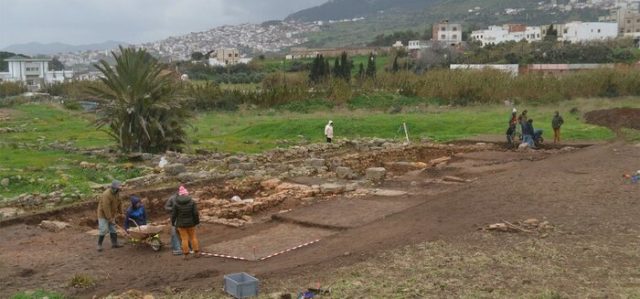
An assemblage of archeologists from the University of Cadiz in Spain have discovered the ruins of a Roman moat at Tamuda, an archeology site near Tetouan in northern Morocco.
The Spanish team has been excavating the Tamuda site for a decade. The research was primarily funded by the Spanish Ministry of Culture and private Spanish organization Palarq.
The Roman moat is an important discovery because it may be the first archeological finding of this kind in Morocco, stated the University of Cadiz in a press release.
It is likely to be part of a Roman military fort and would have been built around a camp, as part of a well-known Roman defensive strategy.
The ancient moat likely dates from the first century AD, during the creation of the Roman province Mauretania Tingitana. Professor Bernal from the University of Cadiz confirmed that the team would be carrying out more excavations at the site.
The excavation of the Tamuda site is a long-term project between Morocco and Spain. It was set up through a bilateral agreement between the Ministry of Culture of Morocco and the University of Cadiz.
Archeologists and researchers participating in the project come from Spain, Morocco, Argentina, Colombia, Ecuador, and Mexico, “making this important Moroccan pre-Islamic site an active international training laboratory, ” stated Professor Darío Bernal Casasola from the University of Cadiz.
The site was first discovered in 1921 by Spanish archeologist Cesar Luis de Montalbán.
We have an affiliate program designed for content creators and Affiliate marketers, who would like to sell this product, please click here for affiliate program details. Our affiliate program is designed to help you monetize your screen time.
During excavations in Eastern Sudan, the scientists from the Wrocław University’s Institute of Archeology found remnants of the humanoids’ presence which tell the untold story of the different phases of human species migration from half a million years ago. Instytut Archeologii Uniwersytetu Wrocławskiego/Facebook
A group of Polish archeologists have uncovered sensational proof that Homo Erectus, the ancestor of today’s humans, spread around the globe using previously undiscovered migration routes.
During excavations in Eastern Sudan, the scientists from the Wrocław University’s Institute of Archeology found remnants of the humanoids’ presence which tell the untold story of the different phases of human species migration from half a million years ago.
Discoveries in the Eastern Desert also confirm the long coexistence of Homo erectus with Homo sapiens in Africa: it is a period of at least 100,000 years, falling between 300,000 and 200,000 years ago. Both species lived there simultaneously.Instytut Archeologii Uniwersytetu Wrocławskiego/Facebook
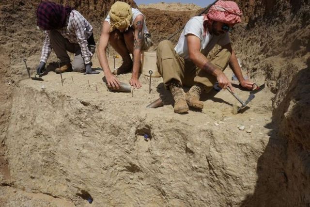
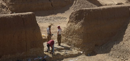
The Polish archeologists, together with colleagues from Germany, Saudi Arabia, South Korea, and the United States decided to conduct their research north of the area, which is usually perceived as the cradle of humanity (along the Great Rift Valley, from Mozambique to the Red Sea) – the Eastern Desert in Sudan.
Enticed by the news, that gold miners in the area were uncovering prehistoric tools, the scientist not only confirmed this information but came across a lot more.
Enticed by the news, that gold miners in the area were uncovering prehistoric tools, the scientist not only confirmed this information but came across a lot more.Instytut Archeologii Uniwersytetu Wrocławskiego/Facebook
On March 6th, the archeologists summarized their project on the Institute of Archeology’s Facebook: “We just finished the last season of excavations in Sudan, which are carried out by our Institute in collaboration with Museum of Archaeology in Gdansk and Neelian University in Khartoum.
“This international project entitled ‘Homo erectus on the path to Eurasia…’ is focused on remains of Pleistocene settlement in the Eastern Desert. During this season we excavated four sites which yielded many finds.
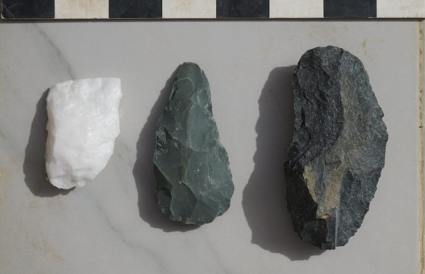
“The oldest artifacts, which we found at archaeological site EDAR 7, are dated to 0,5 Ma [500 thousand years ago] and related to early middle Pleistocene Acheulean culture. This is the oldest known archaeological site in NE Africa.”
Homo Erectus migrations from Africa. PAP Infographics/PAP
What they found was that Homo Erectus traveled outside of Africa not only along the Nile river but also through what is now a desert which used to be a humid area with plants and rivers leading to the Red Sea.
Discoveries in the Eastern Desert also confirm the long coexistence of Homo erectus with Homo sapiens in Africa: it is a period of at least 100,000 years, falling between 300,000 and 200,000 years ago. Both species lived there simultaneously, although one gave birth to the other.
The archeologists, led by Wrocław University’s Prof. Mirosław Masojć (pictured), discovered “… an assemblage of artifacts containing, among others, choppers and chopping tools, bifacial tools (hand axes and cleavers) and big flake tools.”Instytut Archeologii Uniwersytetu Wrocławskiego
The archeologists, led by Wrocław University’s Prof. Mirosław Masojć reveal they discovered “… an assemblage of artifacts containing, among others, choppers and chopping tools, bifacial tools (hand axes and cleavers) and big flake tools.
“Younger finds from the Middle Stone Age, which were manufactured using the Levallois method, can be linked to the settlement of this region by anatomically modern humans (Homo sapiens).
“Every day, we covered 90 kilometers in the desert from our base in Atbara to the sites. In the afternoons, after finishing field work, we devoted ourselves to analyses and recording of our artifacts. Some of the tools were chosen to be transported to Poland, which will allow us to conduct microscopic use-wear analyses.”
We have an affiliate program designed for content creators and Affiliate marketers, who would like to sell this product, please click here for affiliate program details. Our affiliate program is designed to help you monetize your screen time.
Entangled deep in the root balls of enormous trees toppled by Hurricane Michael, which ripped through Florida last October, was an archaeological treasure: ammunition and artifacts from Fort Gadsden, a site occupied by one of the largest communities of freed slaves in the early 1800s.
On July 27, 1816, the U.S. Navy was firing shotsat the fort (then called the “Negro Fort”), when one shot hit a storage unit filled with ammunition, leading to an explosion that killed hundreds of African Americans.
Some of that ammunition, along with a number of other 19th-century artifacts from the fort, recently came to the surface when the Category-5 hurricane ripped up trees in the area.
The fort site has been closed to the public because of the damage from the hurricane.
But “while we were reeling from the shock of the impact of the storm,” the site was listed under the National Park Service’s Underground Railroad Network to Freedom, which made the spot eligible for grants, said study researcher and archaeologist Rhonda Kimbrough, heritage program manager with the National Forests in Florida, part of the U.S. Department of Agriculture’s Forest Service.
Soon after that, the Southeast Archeological Center, part of the National Park Service, in collaboration with the Forest Service, received a $15,000 grant to excavate the artifacts uprooted by the storm, as was first reported by the Tallahassee Democrat.
“This site is really a pivotal point in our nation’s history,” Kimbrough said. It was the “nexus of freedom and slavery resistance.”
The fort, part of the Prospect Bluff Historic Sites in Florida, was built by the British during the War of 1812. Occupying the site were former slaves called Maroons, freed by their pledge of allegiance to the British military. But they lived alongside a mix of different cultures, including Red Stick Creeks (the anti-U.S. faction of a Native American tribe that had fled to the site after the Creek War of 1813-1814), a faction of Choctaw and other tribes, and, of course, the British.
For the next couple of years, at any given day, as many as 3,500 to 5,000 people were living there, Kimbrough told Live Science. But when the War of 1812 ended, the British left the fort at the helm of a former African American slave and left the area. Without the British settlers, the fort’s population fell significantly.
In 1816, U.S. forces attacked the fort. A week of fighting ended in devastation for the fort’s occupants when a single shot from the U.S. troops blew up the stash of ammunition, killing around 270 of the 320 people still living there, Kimbrough said. Those who didn’t die immediately later died from their injuries or at the hands of the U.S. forces.
“It was just devastating,” Kimbrough said. When you “have that kind of explosion from what had been a storehouse of military weaponry, you’re going to have stuff scattered everywhere, just everywhere.”
Root balls tangled up in history
Indeed, when Hurricane Michael uprooted around 100 of the site’s trees — mostly oaks and pines, with a few magnolias — the storm also uprooted musket balls and other military artillery. Tangled up in the mix were 19th-century European ceramics, such as blue-shell-edged pearlware, brown salt-blazed English ceramics, and majolica, a type of colorful Italian pottery.
Through a process called bioturbation, various organisms had, over the years, churned the soil and buried the artifacts deep in the ground.
The trees moved the artifacts around with their roots and blanketed the objects with leaves. Tortoises and other animals aided the process by burrowing holes, and humans did their part by trampling the grounds, logging and extracting turpentine. Even weather events, such as storms and winds, participated in the cover-up.
But now, archaeologists are trying to figure out which pieces belonged to which cultures. The researchers hope to eventually find a ceramic type or a cultural marker that they can use to say definitively whether an artifact comes from a maroon community, Kimbrough said.
Archaeologists are also comparing what they found and where they found it to historical records, including an 1815 map that depicts the locations of fortifications, houses, and other structures.
We have an affiliate program designed for content creators and Affiliate marketers, who would like to sell this product, please click here for affiliate program details. Our affiliate program is designed to help you monetize your screen time.
This group of scientists have discovered some unusual types of methane escaping from the deep earth in hundreds of locations.
Located high on a mountain top in southwest Turkey, the ground breathes fire. This place is known as the Flames of Chimaera, they have burned for millenniums.
Local myth long held that these fires were the breath of a monster — part goat, part snake, part lion. Today we know the fuel for this flaming mountaintop is gas escaping from deep within the earth. But it doesn’t come from the decay of ancient plant, algae or animal life, like fossil fuels.
Instead, this gas comes from a chemical reaction inside rocks. And a series of studies published by a group of international scientists known as the Deep Carbon Observatory is showing that this source of gas is more common on our planet than previously known.
“We have discovered these unusual types of methane in many, many sites. It’s not a rare phenomenon,” said Giuseppe Etiope, a member of the group who helped discover the cause of the flames of Chimaera in 2014.
Over the past decade, the observatory’s community of scientists has found hundreds of gas deposits in more than 20 countries and several spots at the bottom of the sea that is similar to the Flames of Chimaera. And they’ve learned that the recipe for these gas emissions is far more complex than previously thought.
“We now have a better understanding of the different way we can make methane on Earth. There’s not only the biological regime as we know it,” said Bénédicte Menez, a geomicrobiologist at the Institut de Physique du Globe de Paris.
Abiotic methane, as it’s called, doesn’t involve decayed plants, animals or algae trapped in sedimentary rocks, like biotic methane. The chemical reactions that produce these gasses involve water and rocks sometimes miles below Earth’s surface.
For years, Deep Carbon Observatory researchers have collected and analyzed gas samples from hundreds of diverse sites. And using special tools to figure out where the methane came from, they’ve discovered Earth’s basic recipe: Take hydrogen from water. Mix with inorganic carbon from minerals or gas. Add another metal-rich mineral to get the process going, and voilà — abiotic methane.
The hydrogen often comes from serpentinization, when water percolates usually through rocks from the mantle.
But the recipe varies. Different sites may use different minerals or carbons sourced from their environments:
Hydrogen may come from friction, or radiolysis, instead of serpentinization. Temperatures may range from below 250 degrees Fahrenheit, which can still support life, to some 900 degrees Fahrenheit, which can’t.
So the fires of Chimaera were the result of carbon-dioxide-rich limestone, or calcium carbonate and hydrogen-rich serpentinized rocks that were doused by rainwater.
By contrast, in the ocean, at sites like the Lost City hydrothermal vent field, most methane formed under the higher temperatures produced when once-buried mantle rocks were exposed and serpentinized by circulating seawater.
In each case, we see chemosynthesis — the deep earth version of photosynthesis. Only its energy comes from a chemical reaction, not the sun. Both processes transform inorganic molecules to organic products life can use, which is the basis for all ecosystems on the planet.
In some instances, chemosynthesis also produces amino acids, the building blocks of life.
With the new tools designed to study Earth’s subsurface, researchers can determine whether methane came from ancient life or lifeless rocks. In doing so, they also reveal secrets about how life may have emerged on this planet — and the possibility for life elsewhere, like inside Mars or on the ocean floor of Saturn’s icy moon, Enceladus.
Scientists like Dr. Menez think chemosynthesis may have come before photosynthesis and allowed for the emergence of microbes that eat and produce methane. “We know that life did not emerge from scratch,” she said.
And finding parallels in the ways living microbes and lifeless chemical reactions produce methane, the microbes may contain clues about their origin too. Early in Earth’s history, “life may have mimicked geological processes that naturally occurred,” she said.
In the future, the researchers hope to learn how much of this methane is out there and where is it being stored.
We have an affiliate program designed for content creators and Affiliate marketers, who would like to sell this product, please click here for affiliate program details. Our affiliate program is designed to help you monetize your screen time.
The flash from the impact of the meteorite on the eclipsed Moon, seen as the dot at the top left (indicated by the arrow), as recorded by two of the telescopes operating in the framework of the MIDAS Survey from Sevilla (Spain) on 2019 January 21. Credit: J. M. Madiedo / MIDAS
Observers who were watching January’s total eclipse of the Moon witnessed a rare event, a short-lived flash as a meteorite hit the lunar surface. Spanish astronomers now think the space rock collided with the Moon at 61,000 kilometers an hour, excavating a crater 10 to 15 meters across. Prof. Jose Maria Madiedo of the University of Huelva and Dr. Jose L. Ortiz of the Institute of Astrophysics of Andalusia publish their results in a new paper in Monthly Notices of the Royal Astronomical Society.
Total lunar eclipses take place when the Moon moves completely into the shadow of the Earth. The Moon takes on a red color – the result of scattered sunlight refracted through the Earth’s atmosphere – but is much darker than normal. These spectacular events are regularly observed by astronomers and the wider public alike.
The most recent lunar eclipse took place on 21 January 2019, with observers in North and South America and western Europe enjoying the best view. At 0441 GMT, just after the total phase of the eclipse began, a flash was seen on the lunar surface. Widespread reports from amateur astronomers indicated the flash – attributed to a meteorite impact – was bright enough to be seen with the naked eye.
Madiedo and Ortiz operate the Moon Impacts Detection and Analysis System (MIDAS), using eight telescopes in the south of Spain to monitor the lunar surface. Video footage from MIDAS recorded the moment of impact.
The impact flash lasted 0.28 seconds and is the first ever filmed during a lunar eclipse, despite a number of earlier attempts.
“Something inside of me told me that this time would be the time”, said Madiedo, who was impressed when he observed the event, as it was brighter than most of the events regularly detected by the survey.
Unlike the Earth, the Moon has no atmosphere to protect it and so even small rocks can hit its surface. Since these impacts take place at huge speeds, the rocks are instantaneously vaporized at the impact site, producing an expanding plume of debris whose glow can be detected from our planet as short-duration flashes.
MIDAS telescopes observed the impact flash at multiple wavelengths (different colors of light), improving the analysis of the event. Madiedo and Ortiz conclude that the incoming rock had a mass of 45kg, measured 30 to 60 centimeters across, and hit the surface at 61,000 kilometers an hour. The impact site is close to the crater Lagrange H, near the west-south-west portion of the lunar limb.
The two scientists assess the impact energy as equivalent to 1.5 tonnes of TNT, enough to create a crater up to 15 meters across, or about the size of two double-decker buses side by side. The debris ejected is estimated to have reached a peak temperature of 5400 degrees Celsius, roughly the same as the surface of the Sun.
Madiedo comments: “It would be impossible to reproduce these high-speed collisions in a lab on Earth. Observing flashes is a great way to test our ideas on exactly what happens when a meteorite collides with the Moon.”
The team plan to continue monitoring meteorite impacts on the lunar surface, not least to understand the risk they present to astronauts, set to return to the Moon in the next decade.
Paper: Multiwavelength observations of a bright impact flash during the January 2019 total lunar eclipse”, J. M. Madiedo et al., MNRAS (pdf)
We have an affiliate program designed for content creators and Affiliate marketers, who would like to sell this product, please click here for affiliate program details. Our affiliate program is designed to help you monetize your screen time.
A drug bust took a strange turn when police took a lookout parrot into custody as part of a drug bust that happened in Brazil recently.
The bird was trained by its owner in the northern city of Teresina to cry out “Mom, Police” whenever law enforcement approached the house. O Globo reported that last week, even though the parrot did as it was trained, police were able to enter a home and arrest its owner and his daughter on drug trafficking charges.
Officers said they found crack cocaine inside. The daughter was allegedly hiding marijuana in her underwear but was released after a short time in custody.
The report says a veterinarian has determined the bird has lived the first five years of its life in captivity and must be taught how to fly before it can be released into the wild.
Volunteers from a local zoo are offering to take on that task.
We have an affiliate program designed for content creators and Affiliate marketers, who would like to sell this product, please click here for affiliate program details. Our affiliate program is designed to help you monetize your screen time.
by N.Morgan NASA's InSight lander captured a series of sunrise and sunset images.
NASA's InSight lander used the Instrument Deployment Camera (IDC) on the end of its robotic arm to image this sunset on Mars. This color-corrected version more accurately shows the image as the human eye would see it. Credit: NASA/JPL-Caltech
The camera on the spacecraft's robotic arm snapped the photos on April 24 and 25, the 145th Martian day, or sol, of the mission. In local Mars time, the shots were taken starting around 5:30 a.m. and then again starting around 6:30 p.m. As a bonus, a camera under the lander's deck also caught clouds drifting across the Martian sky at sunset.
These images are available as both "raw" and color-corrected versions. It's easier to see some details in the raw versions, but the latter more accurately show the images as the human eye would see them. Much farther from Mars than it is from Earth, the Sun appears only about two-thirds the size that it does when viewed from Earth.
NASA's InSight lander used the Instrument Deployment Camera (IDC) on the end of its robotic arm to image this sunset on Mars on April 25, 2019, the 145th Martian day, or sol, of the mission. This was taken around 6:30 p.m. Mars local time. Credit: NASA/JPL-Caltech
NASA's InSight lander used the Instrument Deployment Camera (IDC) on the end of its robotic arm to image this sunset on Mars. This color-corrected version more accurately shows the image as the human eye would see it. Credit: NASA/JPL-Caltech
This is actually the second time InSight has captured these daily events: The camera took practice shots on March 2 and 10. "It's been a tradition for Mars missions to capture sunrises and sunsets," said Justin Maki, InSight science team co-investigator and imaging lead at NASA's Jet Propulsion Laboratory in Pasadena, California. "With many of our primary imaging tasks complete, we decided to capture the sunrise and sunset as seen from another world."
The first mission to send back such images was the Viking 1 lander, which captured a sunset on Aug. 21, 1976; Viking 2 captured a sunrise on June 14, 1978. Since then, both sunrises and sunsets have been recorded by the Spirit, Opportunity and Curiosity rovers, among other missions.
NASA's InSight used its Instrument Context Camera (ICC) beneath the lander's deck to image these drifting clouds at sunset. NASA's InSight used its Instrument Context Camera (ICC) beneath the lander's deck to image these drifting clouds at sunset. This series of images was taken on April 25, 2019, the 145th Martian day, or sol, of the mission, starting at around 6:30 p.m. Mars local time. Credit: NASA/JPL-Caltech
JPL manages InSight for NASA's Science Mission Directorate. InSight is part of NASA's Discovery Program, managed by the agency's Marshall Space Flight Center in Huntsville, Alabama. Lockheed Martin Space in Denver built the InSight spacecraft, including its cruise stage and lander, and supports spacecraft operations for the mission.
A number of European partners, including France's Centre National d'Études Spatiales (CNES) and the German Aerospace Center (DLR), are supporting the InSight mission.
CNES provided the Seismic Experiment for Interior Structure (SEIS) instrument to NASA, with the principal investigator at IPGP (Institut de Physique du Globe de Paris). Significant contributions for SEIS came from IPGP; the Max Planck Institute for Solar System Research (MPS) in Germany; the Swiss Federal Institute of Technology (ETH Zurich) in Switzerland; Imperial
College London and Oxford University in the United Kingdom; and JPL. DLR provided the Heat Flow and Physical Properties Package (HP3) instrument, with significant contributions from the Space Research Center (CBK) of the Polish Academy of Sciences and Astronika in Poland. Spain’s Centro de Astrobiología (CAB) supplied the temperature and wind sensors.
We have an affiliate program designed for content creators and Affiliate marketers, who would like to sell this product, please click here for affiliate program details. Our affiliate program is designed to help you monetize your screen time.


 The archeologists, led by Wrocław University’s Prof. Mirosław Masojć (pictured), discovered “… an assemblage of artifacts containing, among others, choppers and chopping tools, bifacial tools (hand axes and cleavers) and big flake tools. ”Instytut Archeologii Uniwersytetu Wrocławskiego


